Synthetic Aperture Radar (SAR) from Satellite Imagery
Risk Reduction Category
Computer vision and situational awareness
Technology Description
Data from Synthetic Aperture Radar (SAR) is captured by equipment mounted on low earth orbiting satellites. Normally, satellites orbit in a North-South direction and view a swath of some width as they travel. The width and the spatial resolution are dictated by the purpose and requirements of the collection.
SAR operates on the fundamental radar principle, by emitting energy and sensing the energy being reflected by the subject. Synthetic aperture refers to the technique by which very high resolution can be achieved by propelling the transmitter and receiver over a distance while focusing on the subject. For the wavelengths needed to achieve high resolution of around 10 m, an impractically long antenna, on the order of 2.5 miles long, would normally be required. However, a similar result can be achieved by taking multiple captures over that distance with a much smaller antenna.

Satellite imagery of a right-of-way (left: optical image, right: processed SAR image) [1]
SAR does not require visible light, as it provides the radiating energy source. It can therefore be used day or night and is unincumbered by clouds and smoke. Properties of the energy being emitted, such as the wavelength and polarization, can be optimized for desired results; for example, reflecting from the surface of a tree canopy versus penetrating deeper into the tree canopy.
Use Case Description
Attaining a comprehensive overview of damage severity across a wide area immediately after severe weather is a challenging task. Typically, the storm danger must pass, and daylight is essential before assessors can safely identify damage extent and location of access-obstacles. The damage assessment process is also very labor intensive, at times requiring days to gain full visibility of damage from severe winds, hurricanes, or tornadoes. Synthetic aperture radar may offer an improved approach to damage assessment. Current satellite technology provides the availability to acquire a SAR image four times per day or once every six hours, and this frequency may improve as more SAR enabled satellites are launched. Because these are radar images, cloud cover and night-time visibility are non-factors in the image acquisition. [1]
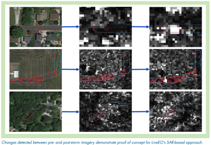
SAR is a good tool for showing changes over time. With pre- and post-storm imagery, change detection algorithms could determine where vegetation and structures are no longer present in their original location or appear to have fallen. By comparing the downed trees to the geospatial locations of the lines and structures, the vegetation damage may provide early insights into likely locations of power system damage. The approach may effectively project storm damage locations and severity before damage assessors can safely get out to start their work.
Technical Readiness (Commercial Availability)
SAR has existed for at least 10 years and is currently being collected via satellite routinely for public and private use. Both historical collections and ongoing collections are available to the public at the following URL, which is an opportunity for an introductory glimpse at example SAR data for those unfamiliar with the topic: https://search.earthdata.nasa.gov/search?q=SAR
With 2022 era availabilty, each opportunity to acquire a SAR image by satellite can happen as frequently as four times per day or once every six hours. Data availability is expected to improve as more SAR-enabled satellites are launched. The storm use case would require working with a vendor to acquire imagery on specific dates of precisely the area of interest and with high spatial resolution. In many cases, two vendors will be required, as the satellite vendor is concerned with positioning and data capture, whereas the processing of SAR data is another specialty.
For best results, the use case ideally would include three collections in same area immediately before the storm and in dry conditions (rain on leaves can interfere with wave refraction). Another consideration is the orientation of orbit: ascending pass versus descending pass. For better performance of the image comparison, all data would ideally be captured in the same direction of orbit.
SAR Data Providers
-
Capella Space (USA)
Commercial satellites producing SAR data. Analytics partners provide change detection solutions.
-
ICEYE (Finland)
Commercial satellites for purchase, lease, or for data collections.
-
LiveEO (Germany)
SAR image processor with focus on infrastructure such as railways, electric power grid, and pipelines.
Implementations / Deployments
In 2021, EPRI, Ameren, and Fortis BC sponsored a proof-of-concept field demonstration with SAR provider LiveEO [2]. Objectives of the study were focused on feasibility of using the proven technology for the unique application of storm damage assessment. Specifically, the team was interested in the following aspects:
- the time required to task satellites and capture imagery,
- the time required to process and analyze SAR imagery,
- the resolution and accuracy of the imagery, and
- the effectiveness of AI-based algorithms to assess storm damage.

LiveEO analyzed pre- and post-storm imagery and detected a number of plausible changes in conditions that can be attributed to fallen trees and other damage. Results were provided to Ameren within 17 hours of post-storm imagery acquisition, demonstrating the feasibility of adequate turnaround in producing actionable information relating to storm damage even with the existing constellations of satellites in orbit. Some challenges were identified during the field trial, the details of which are publicly available. [2]
References
[1] Assessment of Satellite Derived Radar Imagery for Initial Storm Damage Assessment. EPRI, Palo Alto, CA: 2023. 3002026273.