Aerial Asset Inspections - E-Field Sensing
Risk Reduction Category
Technology Description
Today, utilities commonly use imagery from unmanned aerial systems (UAS) to improve their vantage point when inspecting overhead assets. As of 2023, most UAS used in this way are manually operated, however, as technology improves and regulations are more favorable, automation is increasingly possible. As an example, to supplement manual flight control, UAS are now capable of identifying poles and flying a prescribed path around each pole in order to capture images. While imagery alone is often sufficient for asset inspections, the success of an inspection is dependent on the quality of imagery, which is subject to camera positioning, glare from sunlight, shadowing, and other interference.
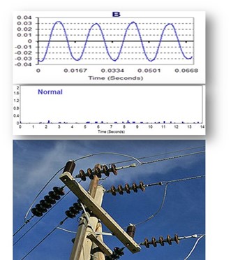
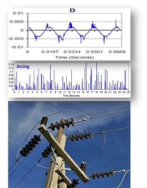
Supplemental information from electric field sensors could improve visual inspections. The idea of an electric field sensor mounted to UAS is an emerging approach for inspecting assets to detect pre-failure conditions. It would be used as a supplement to visual imagery rather than a replacement. As an enhancement to visual inspections, an e-field sensor on the same UAS can improve anomaly detection by capturing arcing signatures. The utility can use this additional layer of intelligence to identify whether an asset needs to be replaced or put on a watch list. In the figures below, compare the normal condition (left) to the abnormal condition (right) where visual inspection alone is unable to discern this anomaly.


Technical Readiness (Commercial Availability)
Electric field sensing is a mature technology and has a very wide range of applications. Additionally, mounting e-field sensors to an unmanned aerial system is also used for a variety of applications. What is innovative is the idea of identifying unique signatures that could warn of insipient failures on utility assets. To deploy such a device, important hardware and software requirements for this application are:
- Signal Analyses, either real-time or post-processed
- Waveform anomaly detection
- Spectrum analysis
- Geo-locating
- Imagery from camera
- Local data storage or streaming to ground support
Implementations/Deployments
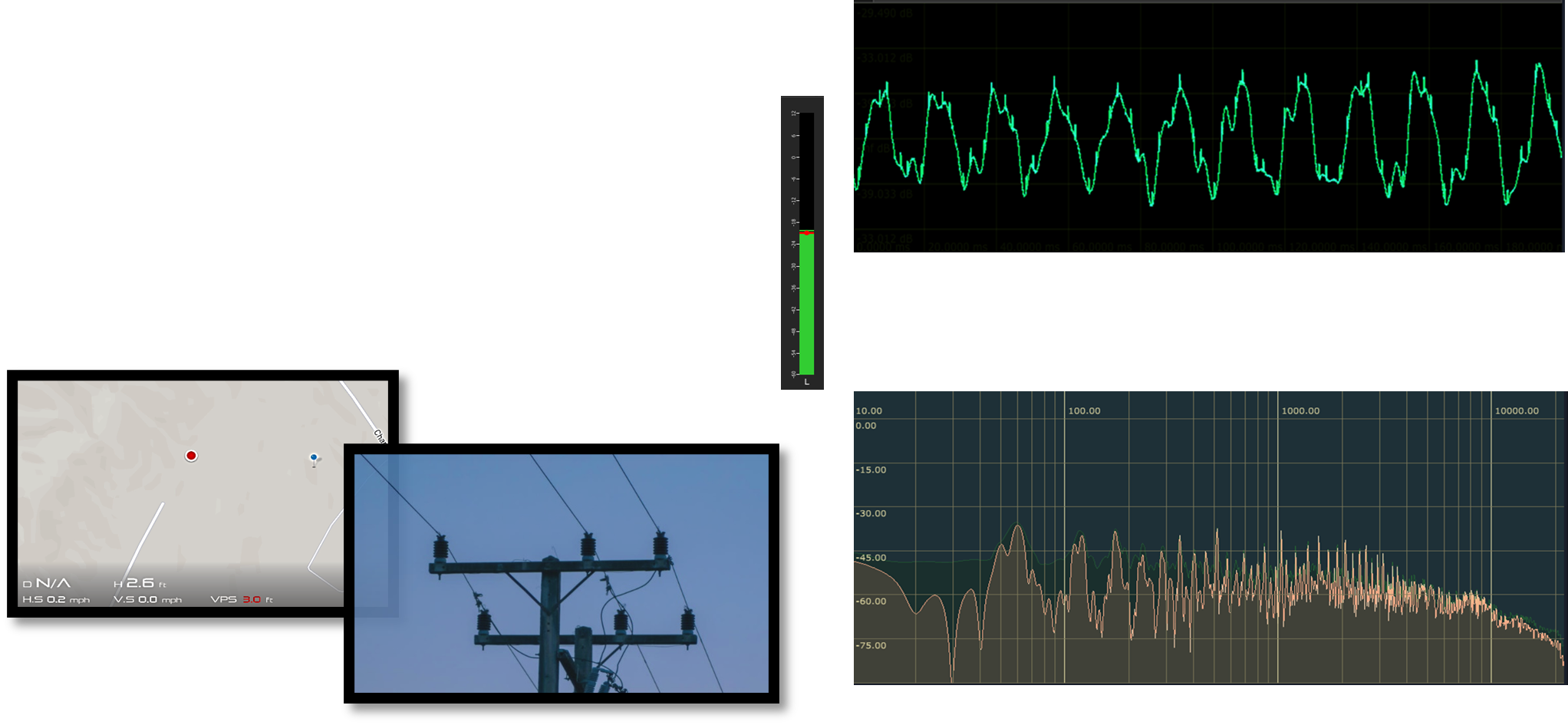
As an emerging application, EPRI is not aware of any commercial vendors innovating in this space. However, in 2019, EPRI developed US Patent 10,501,181 B1 for “Method and Apparatus for Aerial Scanning and Detection of Contact Voltages and Distinguishing Between Normal and Abnormal Electric Fields.” [1] This technology has not yet been field tested outside of proof-of-concept tests in a controlled environment. Snapshots from an experimental trial are shown below, including the following real-time data:
- Geolocation (left)
- Visual imagery (left)
- Waveform capture and streaming (top right)
- Spectrum analysis (bottom right)

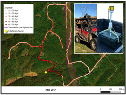
Another EPRI innovation closely related to the topic is what EPRI calls their Portable Radiated Emissions Measurement System, version 2 (PREMS II). EPRI has created a mobile system built on a roboticized platform to enable efficient, accurate, and repeatable electric field measurements over broad geographical areas. See figure below. The tool is designed to quickly and efficiently pinpoint sources of radiated emissions. With a simple web-based interface, PREMS II connects to a suite of available sensors to allow for expedient capturing of GPS coordinated sensor data. As proven in two use cases in 2020 using prototype configurations, the PREMS II system helps the user to observe electric field and frequency spectrum through heat maps overlaid on satellite imagery. This technology can enable utilities to accelerate the measurement and detection of the sources of radiated emissions issues, thereby expediting mitigation and promoting compatibility between the electrical grid, end-use customers, and a myriad of related systems. This system offers a ground-based, versus aerial platform on which to build additional intelligence to potentially detect insipient fault signatures from failing overhead assets.

Innovations as of Mid 2023
As a related technology, Manifold Robotics, with financial support from New York State Energy Research and Development Authority (NYSERDA) developed an e-field-guided drone that uses electric fields from powerlines to navigate along overhead assets. [2] This technology is used to aid the navigation and positioning of the drone in order to improve the capture of visual imagery. While the usage of e-field data differs in this application, it offers a hardware platform for further developing e-field signature recognition.
References
[1] https://image-ppubs.uspto.gov/dirsearch-public/print/downloadPdf/10501181